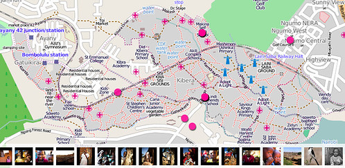
From the Map Kibera project,
Kibera in Nairobi, Kenya, widely known as Africa’s largest slum, remains a blank spot on the map. Without basic knowledge of the geography and resources of Kibera it is impossible to have an informed discussion on how to improve the lives of residents.
Using data collected by Map Kibera, a map has been created and made available to anyone through the wonderful Open Street Map.
Thanks to the Creative Commons Attribution-ShareAlike 2.0 license in use at Open Street Map, we’re able to make the Kibera map tiles available on Flickr.
Because the map is created by residents, it has more than just roads and ways. It also shows churches, medical centers, restrooms, Adopt A Light locations, water collection centers, and much more.

For more info on the Map Kibera project check out their blog. If you really want to geo-geek out on how the map data was collected, they posted “Some notes on Map Kibera mapping“.