
The Flickr Foundation was established in 2022 with the mission to keep Flickr pictures visible for 100 years. As part of our work, we look after the Flickr Commons, a unique collection of historical photographs from cultural institutions all around the world.
Earlier this year, we launched the Commons Explorer, which gives you a variety of ways to browse the collection, and we recently added a map feature. You might find photos of the town where you grew up, your favorite place to visit, or even where you are right now.
Here’s a quick tour of some photographs we’ve discovered using the map.
Exploration at the edge of the world
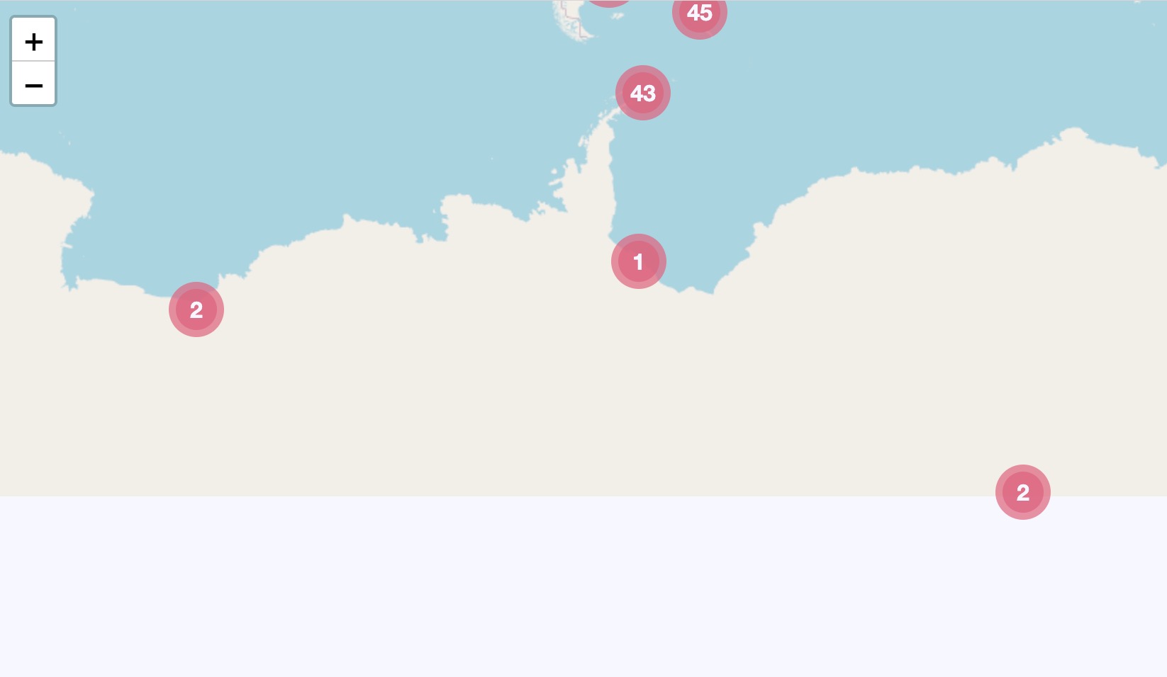
When we first built the map, our eyes were drawn to the blob of photos at the very bottom. There are lots of photos taken in populated areas like the US and Europe, but who had a camera at the South Pole? Antarctic explorers!
Roald Amunden was a Norwegian polar explorer who led the first crew to successfully reach the South Pole. They used skis and dog sleds to traverse the hostile terrain, and they arrived at the pole on December 14, 1911. The National Library of Norway have uploaded their photos to Flickr, in the Sydpol-ekspedisjonen album.

Amundsen isn’t the only polar explorer in the Flickr Commons. In 1914, Ernest Shackleton tried to make the first land crossing of Antarctica – but he was trapped in the ice, and forced to abandon ship. Over a hundred photographs survived, and the State Library of New South Wales added them to the Flickr Commons – including a photo of Shackleton’s doomed ship Endurance.
All ships set sail from somewhere
As we moved around the map, we found large clusters of photos in specific small areas – indicating a possible local archive or museum, dedicated to the history of each of these places.
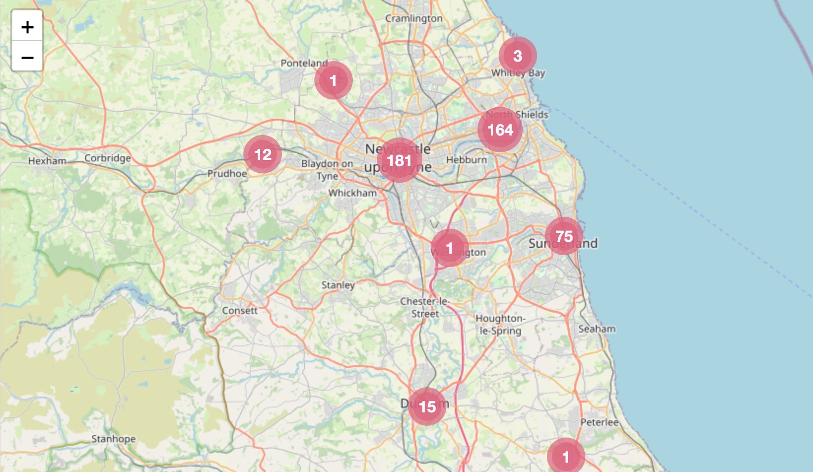
In the north of England, Newcastle is one example – the map has more than 400 photos from the Tyne & Wear Archives. This region has a rich industrial history, which is reflected in the photos on the Flickr Commons.
Ships built in the north of England traveled all around the world. The RMS Mauretania was built in 1906 on the River Tyne. When she was built, she was the largest ship in the world. The barely-visible workmen in these photos give you a sense of her size and scale.


The area was also a manufacturing hub, such as in this photo from the factory for Wright’s Biscuits. The company began making biscuits and cakes in the late eighteenth century, and their workers helped keep the British Army fed during the Second World War.

Newcastle was also a center of coal mining. Many of those mines have now closed, and their final days are captured on Flickr. There’s an album of photos taken by documentary photographer Les Golding, showing miners and mine equipment at the Wearmouth Colliery. Just a week later, the last shift clocked off and the mine was closed.

Illustrations of intriguing islands
Most of the map markers are above landmass, mostly cities and built-up areas. Our eye was drawn to the nearly 400 in the middle of the Pacific Ocean, taken on the Hawaiian archipelago. The locations are so granular, we can distinguish photos taken on different islands.
In the 1970s, the US Environment Protection Agency hired dozens of photographers to document America as part of the Documerica project. Many of these photographs have been uploaded to Flickr Commons by the US National Archives, including Charles O’Rear’s trip to Hawaii. He took dozens of photos which give us a sense of everyday life in Hawaii.


Documerica was also about capturing the environmental issues facing America. His photos highlight the tension between Hawaii’s stunning natural landscapes and the encroaching pressure to use land for tourism and housing.


New Flickr Commons members on the way!
Make sure to take some time and travel the globe through our Flickr Commons map tool. We’re also very pleased to let you know we’ll be opening the doors to new Flickr Commons members very soon. We’ll be back soon with the first welcome post we’ve had in a while. Yay!